Statistical Spatial Framework (SSF)
Connecting information about people, society and the economy to a location
"The work on global geospatial information management over the past two to three years has confirmed that one of the key challenges is a better integration of geospatial and statistical information as a basis for sound and evidence-based decision-making." The Secretary General of the UN Economic and Social Council 2012
The Australian Bureau of Statistics (ABS) recognised this challenge and responded by developing the Statistical Spatial Framework. This Framework provides Australia with a common approach to connecting people-centric (socio-economic) information to a location, and improves the accessibility and usability of this location-enabled information.
The Statistical Spatial Framework has applicability in any organisation wanting to understand people, society and the economy in the context of place.
What is the Statistical Spatial Framework for Australia?
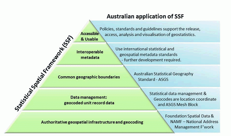
The general Statistical Spatial Framework, developed by the ABS, consists of five elements that are considered essential to integrating geospatial and socio-economic information. The Statistical Spatial Framework for Australia details the Australian implementation of this general Framework. Interest in the general Framework is expected to result in the implementation of similar frameworks in other countries. The framework is shown below.
Image

Description
Geocoding
The foundation of the Statistical Spatial Framework for Australia is the National Address Management Framework (NAMF). NAMF provides a common and consistent approach to establish a location (or geocode) from the address of each person, household or business in a dataset. This location should ideally be obtained from a physical address and not a mailing address.
NAMF has been endorsed by all Australian government jurisdictions and utilises the Geocoded National Address File (G-NAF ®) as the source of address locations for service delivery. This dataset is also available under open data terms at www.data.gov.au.
Data management
Each person, household or business record in a dataset should have associated with it geo-reference information that is based on the geocoded address. To gain the maximum benefit from the geocoded address, the geo-reference information should ideally consist of the address geocode (i.e. a latitude and longitude) and the associated Mesh Block identifier, as defined in the Australian Statistical Geography Standard.
Common geographic boundaries
The Australian Statistical Geography Standard (ASGS) is the common boundary set for analysis, display and reporting of socio-economic information within the Statistical Spatial Framework for Australia. Use of the ASGS will ensure that socio-economic information is available for a consistent, hierarchical set of geographies. In addition, the core ASGS boundary hierarchies have been designed to include approximately equal population numbers within each area, enabling meaningful comparisons of the population and associated human activity between areas. The ASGS boundaries were also designed by the ABS to support flexible reporting. The boundaries range in size from small geographic areas, such as a suburbs and groups of a few urban blocks, through to larger areas, such as a natural resource management areas and regions or cities.
Metadata interoperability
The spatial and statistical communities operate different metadata capabilities. Approaches to ensure that these two metadata environments can work together effectively are being investigated. Existing metadata standards being investigated include: Statistical Data and Metadata Exchange (SDMX), Data Documentation Initiative (DDI), and the international geospatial metadata standard ISO19115. It is important that any dataset that incorporates geo-referencing contains the relevant statistical and spatial metadata to be accessible, understood and useful across the statistical and spatial data-user communities.
Guidance material
Organisations need to be aware of a range of legislative and operational issues when dealing with information about people and businesses; with the most significant issue being the privacy and confidentiality requirements for managing personal and commercial information.
The ABS has in place a number of policies, guidelines and procedures that it is currently reviewing to make them available as reference material for organisations that are seeking to use the Framework to add a location element to their data. The ABS also welcomes input from other organisations that have experience in undertaking similar location focussed tasks. This SSF Guidance Material will provide best practice approaches to address many of the issues associated with location enabling socio-economic data.
Benefits of the Statistical Spatial Framework for Australia
By standardising the process of integrating a range of socio-economic information within a location context, the Framework will empower people and organisations to:
Improve planning for regional economies and communities
Better target service delivery at the local-area level
Engage in more informed community level decision making
Incorporate population, social and economic data into current geospatial analysis.
The Framework will also benefit the considerable efforts currently being made to bring a range of data together to better understand local-area level causes, impacts and responses to national and global concerns, such as natural disasters, climate change and sustainable development.
The Framework will enhance Australia’s environmental, social and economic intelligence in the twenty-first century.
More information
For SSF Guidance Material, see SSF Guidance Material.