ABS Geospatial Roadmap
About
Our strategy for unlocking more value from ABS geospatially enabled statistics, technologies, and capabilities for the next four years. This Roadmap:
- Sets out the ABS vision to maximise the value of geospatial data, capability and technology across the organisation
- Defines principles, objectives and initiatives to achieve this vision
- Outlines the value that geospatial will deliver for ABS and its clients
- Defines and measures the benefits that will be delivered.
Vision
To lead Australia in producing national geospatially enabled statistics that puts location intelligence in the hands of decision makers.
Objectives to achieve our vision
- Partnerships: we will broker partnerships to create efficient and enduring solutions
- Products: we will provide products that make it easier for clients to perform accurate and timely location-based analysis
- Infrastructure: we will continue to invest in geospatial infrastructure to enable production of high-quality geospatially enabled statistics
- Governance: we will improve data access, discoverability and use while meeting privacy and security needs
- Capability: we will foster innovation and support future skills to secure the talent pipeline
- Leadership: we will influence and contribute to the geospatial data profession
Principles to guide delivery
- We geospatially enable small area statistics where we have a clear mandate and there is strong public value
- Protection and privacy are proportionate to value and risk
- We consider location in the design phase of statistical projects
- We take a user-centered approach to product management
- Published geospatially enabled statistics are findable, accessible, interoperable, and reusable (FAIR)
- We value data from new sources and it is efficient to share data with us
Strategic framework
Image

Description
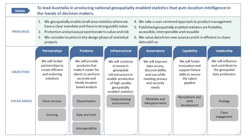
This image outlines the Strategic framework of the ABS Geospatial Roadmap.
- The vision statement of "To lead Australia in producing national geospatially enabled statistics that puts location intelligence in the hands of decision makers.
- The six principles to guide geospatially enabled data action in the ABS are listed next. The six principles are:
- We geospatially enable small area statistics where we have a clear mandate and there is strong public value.
- Protection and privacy proportionate to value and risk.
- We consider location in the design phase of statistical projects.
- We take a user-centred approach to product management.
- Published geospatially enabled statistics are findable, accessible interoperable and reusable.
- We value data from various sources, and its effortless to share data with us.
The 6 objectives central to achieving the vision and their focus areas are listed next:
- Objective: Partnerships: We will broker partnerships to create efficient and enduring solutions. Focus areas: Client services, Sourcing.
- Objective: Products: We will provide products that make it easier for clients to perform accurate and timely location-based analysis. Focus areas: Dissemination, Data and tools, interoperability.
- Objective: Infrastructure: We will continue to invest in geospatial infrastructure to enable production of high-quality geospatially enabled statistics. Focus areas: Geoprocessing environment.
- Objective: Governance: We will improve data access, discoverability and use while meeting privacy and security needs. Focus areas: Metadata and data governance.
- Objective: Capability: We will foster innovation and support future skills to secure the talent pipeline. Focus areas: Recruitment and skills development.
- Objective: Leadership: We will influence and contribute to the geospatial data profession. Focus areas: Strategy, Client engagement.
Context
There is growing demand for more granular geospatially enabled statistical data to inform policy and operational decisions and to assist governments and business in providing better services. This shift is linked to the growth in big data, along with new data integration and analytical advancements enabled by Fourth Industrial Revolution (4IR) technologies.
In addition to the ongoing ABS investment in geospatial, priority government digital investments such as the Australian Climate Service and the Digital Atlas of Australia have secured new funding to enable the ABS to uplift its location data, technologies, and capabilities.
This is the ABS’s first geospatial roadmap. It will help us to target investment across three horizons of work so that we can deliver timelier and more accessible geospatially enabled statistics for our clients and partners.
Why we need a Roadmap
Looking at the ABS operating context out to 2026, the roadmap reflects the changing nature of our business, and identifies a range of drivers and opportunities that can be harnessed to help the ABS fulfil its purpose: to inform Australia’s important decisions by delivering relevant, trusted and objective data, statistics and insights.
| Drivers | Opportunities |
|---|---|
| Untapped data potential – we have a growing library of data assets (including administrative/big data assets) that have the potential to be geospatially enabled | Achieve operational efficiencies such as optimised data acquisition through GIS-enabled route planning and rapid processing of big data using GeoAI |
| Significant new investment in ABS location capability, through the Australian Climate Service and the Digital Atlas of Australia | Unlock productivity improvements through scalable, interoperable, secure and performant foundational infrastructure |
| Increasing costs in a budget-constrained environment as the economy recovers from the global pandemic | Create more value from our own data and data shared with us to make it easier to generate accurate and timely location intelligence |
| Growing client expectations that ABS data will be easy to find, use and in a decision-ready format | Create client-centered products that are findable, accessible, interoperable and reusable |
| New expectations of trust, with data governance and capability increasingly recognised as a driver of public trust | Influence and contribute to the national geospatially enabled data landscape while investing in the capability and future skills of our people |
| Keeping pace with the rapid advances in location-enabled technologies and computing power | Deliver on our promise by investing in location-based data, technologies and capabilities |
What we will focus on
Image

Description
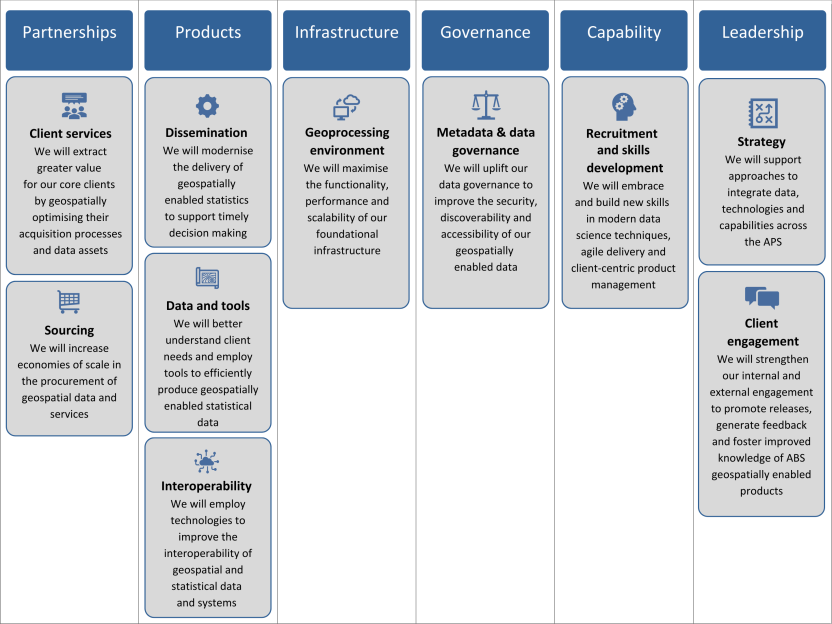
The six detailed objectives are listed, followed by their detailed focus areas:
- Objective: Partnerships. Focus area: Client services: We will extract greater value for our core clients by geospatially optimising their acquisition processes and data assets.
- Objective: Partnerships. Focus area: Sourcing: We will increase economies of scale in the procurement of geospatial data and services.
- Objective: Products. Focus Area: Dissemination: We will modernise the delivery of geospatially enabled statistics to support timely decision making.
- Objective: Products. Focus Area: Data and tools: We will better understand client needs and employ tools to efficiently produce geospatially enabled statistical data.
- Objective: Products. Focus Area: Interoperability: We will employ technologies to improve the interoperability of geospatial and statistical data and systems.
- Objective: Infrastructure. Geoprocessing environment: We will maximise the functionality, performance and scalability of our foundational infrastructure.
- Objective: Governance. Focus area: Metadata and data governance: We will uplift our data governance to improve the security, discoverability and accessibility of our geospatially enabled data.
- Objective: Capability. Focus area: Recruitment and skills development: We will embrace and build new skills in modern data science techniques, agile delivery and client-centric product management.
- Objective: Leadership. Focus area: Strategy: We will support approaches to integrate data, technologies and capabilities across the APS.
- Objective: Leadership. Focus area: Client engagement: We will strengthen our internal and external engagement to promote releases, generate feedback and foster improved knowledge of ABS geospatially enabled products.
How we will get there
| 2022-2023 | 2023-2024 | 2024-25 to 2026 |
|---|---|---|
| Secure a strong base | Build velocity | Sustain value creation |
|
|
|