DataPacks

Census data tools and products
Released
12/04/2022

Overview

DataPacks contain comprehensive data about people, families and dwellings for all Census geographies ranging from Australia down to Statistical Area Level 1 (SA1). They are containers of data based on Census Community Profiles and include digital boundary information, metadata and reference documents to enable you to read the data.

DataPacks are suitable for experienced Census data users who have their own databases or analysis systems. Use DataPacks if you want Community Profile data for numerous geographic areas.

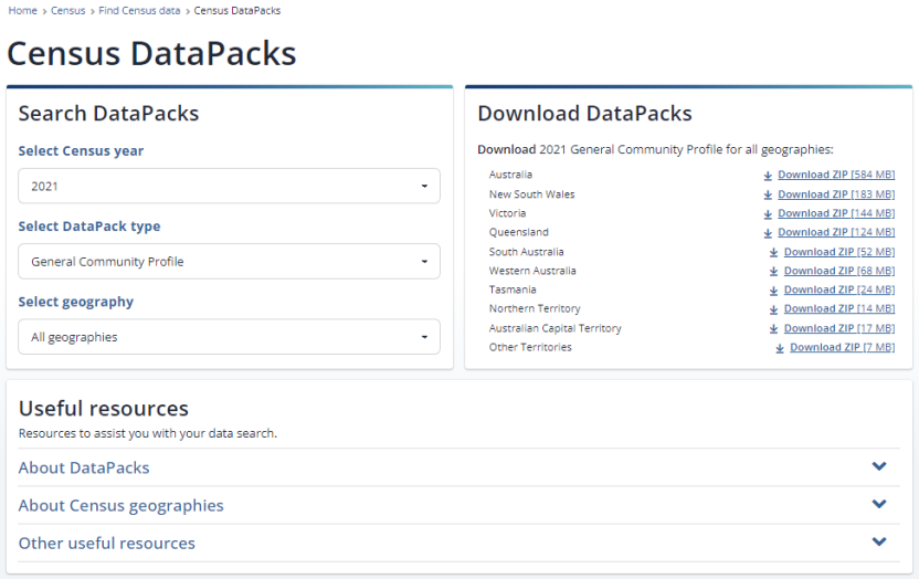
Image of DataPacks user interface.
Image of Census DataPacks interface. This is where users can search and download Census DataPacks.

How to download DataPacks

To access DataPacks, navigate to the Census homepage, select the ‘Find Census data’ tile, select ‘Census data tools’, and then select ‘DataPacks’.

Step 1 - Select which Census year to draw data from

  • Choose from 2011 onwards.

Step 2 - Select the type of DataPack

Step 3 - Select the Geography

  • The available options will depend on which profile has been chosen in Step 2.
  • If you are unsure of which geography to select, see Understanding Census geography.

Step 4 - Select a descriptor type (only required for 2011 Census DataPacks)

  • Step 4 has been removed for 2016 and 2021 DataPacks because they contain short descriptor labels. Metadata for 2016 and 2021 will include supplementary details for sequential and long descriptors. See Descriptor types.

Step 5 – Download your DataPack

  • Download your DataPack by clicking on the link that corresponds to the State or Territory that you want data for.
  • For example, selecting ‘Local Government Areas’ in Step 3, and clicking the blue link next to AUS, downloads data for each of the 566 Local Government Areas in Australia.

Step 6 - Download Geography boundaries (optional - for 2011 and 2016 Census DataPacks only)

  • Download ESRI Shapefile for your mapping software.
  • If you selected ‘All geographies’ in Step 3, you will need to download a digital boundary file for each geography available for that DataPack. To do this, go back to Step 3, select a geography, and download the digital boundary file for that geography. Repeat this until you have downloaded each geography.

Types of DataPacks

DataPacks are based on all Community Profiles with an additional profile.

The Community Profiles in brief are:

General community profile

Aboriginal and Torres Strait Islander people profile

Time series profile

Working population profile

Place of enumeration profile

DataPack templates

DataPack templates are blank DataPacks without data. These templates can be used to understand what data will be released in DataPacks and the format of the files.

To view the DataPack templates, see Download product templates.

What you need to use a DataPack

You will need the following software to use DataPacks:

  • software to access compressed zip files
  • text editor for readme.txt files
  • spreadsheet application (such as Excel) for the Metadata files
  • software to read .csv data files
  • Geographic Information System (GIS) software (optional).

Files contained in a DataPack

DataPacks are downloaded as a .zip file which includes three sub-folders:

Data folder

  • Contains the data for the selected Community Profile in CSV format. The data is located under geography sub-folders.
  • Each CSV file represents a table of data from the selected Community Profile.

Metadata folder

  • Sequential template file (.xlsx) – a template of the selected Community Profile for you to visualise all data cells.
  • 2021 Geography descriptor file (.xlsx) - lists all geographies used in DataPacks by level, code, label and area.
  • Metadata file (.xlsx) - contains information on the table numbers, names, populations and cell descriptor information.

Readme folder

  • The text documents provide help on specific topics and functions for DataPacks.

Descriptor types

Descriptors are column headings in the data files that display each data label. There are three types of descriptors: Sequential, Short and Long.

A descriptor type for 2011 DataPacks will need to be selected before downloading. 2016 and 2021 DataPacks default to short descriptors.

Should you require data using a different descriptor, you can replace headers in the CSV files using descriptor information available in the Metadata contained in the zip file.

The examples below show the different type of descriptors for the same geography.

Short descriptor headings (default for 2016 and 2021)

Sequential descriptor headings

Long descriptor headings

Resources

Back to top of the page