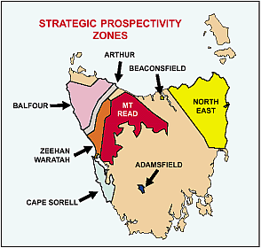
Strategic Prospectivity Zones (SPZ) are recognised regions of high prospectivity for mineral discovery.
SPZs were established under 1993 legislation enacted to provide resource security for the minerals industry. Under this legislation, the status of significant parcels of Crown land within SPZs cannot be changed to a tenure excluding mineral exploration and mining without the approval of both Houses of State Parliament. The approval of the Director of Mines is needed for small parcels of land (less than 500 hectares). If the status of land is changed so that a mineral tenement is voided or diminished in size, the holder may be compensated.
The following map shows Tasmania's SPZs.
 Source: Mineral Resources Tasmania, Annual Review 2000-01
STRATEGIC PROSPECTIVITY ZONES, Tasmania - 30 JUNE 2001
|
 | Metallic
|  | Non-metallic
|
 | Area | Occupied |  | Area | Occupied |
|  |  |  |  |  |
| SPZ | km2 | % |  | km2 | % |
|
| Adamsfield | 68.4 | 92.8 |  | - | - |
| Arthur | 146.5 | 13.2 |  | 1.6 | 0.1 |
| Balfour | 1,064.3 | 27.2 |  | 3.4 | 0.1 |
| Beaconsfield | 19.0 | 99.9 |  | 4.0 | 21.0 |
| Cape Sorell | 676.1 | 48.9 |  | - | - |
| Mount Read | 1,085.1 | 15.1 |  | - | - |
| North East(a) | 678.6 | 7.0 |  | 219.0 | 2.2 |
| Zeehan/Waratah | 292.5 | 16.0 |  | - | - |
- nil or rounded to zero
(a) Figures exclude a special exploration licence that covers 4,337.43 km2 (44.8%) of the SPZ.
Source: Mineral Resources, Tasmania, Annual Review 2000-2001. |
 Print Page
 Print All