 NEW SOUTH WALES
STATE SUMMARY
POPULATION CHANGE IN SYDNEY
POPULATION CHANGE IN THE REMAINDER OF NSW
CENTRES OF POPULATION
LOCAL GOVERNMENT AREA POPULATIONS
STATE SUMMARY
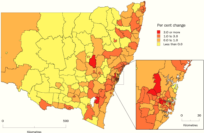
At 30 June 2008 the estimated resident population of New South Wales (NSW) was 6.98 million people, an increase of 79,200 people since June 2007. The NSW growth rate for 2007-08 (1.1%) was higher than the average annual growth rate for the five years to June 2008 (0.9%).
SLA POPULATION CHANGE, New South Wales
- 2007-08
POPULATION CHANGE IN SYDNEY
In the year to June 2008 the population of the Sydney SD increased by 55,000 people (1.3%) to 4.4 million people. The Sydney SD represented around 63% of the NSW population.
Almost all LGAs in Sydney experienced population growth in the year to June 2008. Nine of the ten LGAs with the largest population growth in NSW were within the Sydney SD. Blacktown (C) in western Sydney had the largest population increase of any LGA in NSW, up 5,300 people, followed by the adjacent LGA of Parramatta (C) (4,000 people). Large population growth also occurred in Baulkham Hills (A) (3,300 people) in the north-west, Liverpool (C) (3,200 people) in the south-west, and in the inner-city LGA of Sydney (C) (2,500 people). Within the Sydney SD, LGAs which experienced population decline in 2007-08 were Ashfield (A), in the inner west, as well as Manly (A) and Lane Cove (A) in northern Sydney.
In 2007-08, over half of Sydney's LGAs experienced a growth rate higher than the NSW rate of 1.1%, with around one in five LGAs recording growth rates of 2.0% or more. Auburn (A) in central-western Sydney experienced the fastest growth of any Sydney LGA, at 3.1%, followed by neighbouring Parramatta (C) (2.5%). Other LGAs with fast growth were Strathfield (A) (2.4%) and Canada Bay (A) (2.3%) in the inner west, Camden (A) (2.2%) in the outer south-west and Holroyd (C) (2.1%) in western Sydney.
LGAs WITH LARGEST AND FASTEST POPULATION GROWTH, New South Wales |
|
 | ERP at 30 June | Population Change |
| 2008p | 2007r-2008p |
| LGA | no. | no. | % |
LARGEST GROWTH |
|
| Blacktown (C) | 291 600 | 5 300 | 1.9 |
| Parramatta (C) | 161 900 | 4 000 | 2.5 |
| Baulkham Hills (A) | 171 000 | 3 300 | 2.0 |
| Liverpool (C) | 176 900 | 3 200 | 1.9 |
| Sydney (C) | 172 700 | 2 500 | 1.5 |
FASTEST GROWTH |
|
| Wellington (A) | 8 700 | 370 | 4.4 |
| Auburn (A) | 73 500 | 2 200 | 3.1 |
| Palerang (A) | 13 900 | 390 | 2.9 |
| Tweed (A) | 86 800 | 2 200 | 2.6 |
| Parramatta (C) | 161 900 | 4 000 | 2.5 |
|
POPULATION CHANGE IN THE REMAINDER OF NSW
At June 2008 the population in the remainder of NSW was 2.58 million people (37% of the NSW population). The population had increased by 24,200 people (0.9%) since June 2007. Of all the SDs in the remainder of NSW, the Hunter SD, located on the coast north of Sydney, had the largest population increase (up 6,900 people). Also recording large increases were the coastal SDs of Illawarra (4,400 people), Mid-North Coast and Richmond-Tweed (both 3,700 people). The Far West was the only SD in NSW to experience a population decline, losing 150 people.
The fastest growing SDs in NSW outside Sydney were Richmond-Tweed (1.6%), Mid-North Coast (1.2%), Hunter and South Eastern (both 1.1%). The Central West, Far West, Northern and North Western SDs all recorded growth rates below 0.5%.
Coastal Change
At June 2008 around 20% of the NSW population (1.38 million people) lived in coastal LGAs (LGAs with a boundary adjoining the sea) outside the Sydney SD. Combined, the population of these 21 coastal LGAs increased by 16,100 (1.2%) between June 2007 and June 2008.
As in previous years, all NSW coastal LGAs outside the Sydney SD had population increases, with one-third recording rates higher than the state average of 1.1%. The largest and fastest population increase was in Tweed (A), on the far north coast, with an increase of 2,200 people (2.6%). Large population increases also occurred in Wollongong (C) (up 2,100 people) in the Illawarra SD, and Lake Macquarie (C) (2,000 people) and Newcastle (C) (1,700 people), both in the Hunter region.
Other coastal LGAs experiencing fast population growth were: Port Macquarie-Hastings (A) and Coffs Harbour (C) (both 1.9%) on the mid-north coast, Shellharbour (C) (1.7%) south of Wollongong, and Byron (A) (1.6%) and Ballina (A) (1.5%) on the far north coast.
Inland Population Change
At June 2008 about 17% of the NSW population (1.2 million people) lived in inland NSW LGAs (LGAs not in the Sydney SD or coastal NSW). The combined population of these inland LGAs increased by 8,000 (0.7%) between June 2007 and June 2008.
The largest population increase for an inland LGA in 2007-08 occurred in Maitland (C) (1,100 people) in the Hunter region. Other LGAs with large population increases included the regional centres of Wagga Wagga (C) (920 people), Cessnock (C) (750 people) and Queanbeyan (C) (700 people).
Less than one in five of the 88 inland LGAs in NSW had growth rates higher than the 1.1% recorded for the whole of NSW. The fastest-growing LGA in NSW was Wellington (A) (4.4%), in the central west, largely due to the opening of a new correctional centre. Fast growth rates also occurred in Palerang (A) (2.9%), Queanbeyan (C) (1.8%) and Yass Valley (A) (1.6%), which all share borders with the Australian Capital Territory.
Around half of NSW inland LGAs experienced population decline in 2007-08, indicating the on-going impacts of drought and changes in the mining industry. The largest inland population declines, of around 100 people, were in Broken Hill (C) in the far west, Gwydir (A) and Moree Plains (A) in the north, and Cowra (A) and Bland (A) in central-west NSW.
LGAs WITH LARGEST AND FASTEST POPULATION DECLINE, New South Wales |
|
| ERP at 30 June | Population Change |
| 2008p | 2007r-2008p |
| LGA | no. | no. | % |
LARGEST DECLINE |
|
| Ashfield (A) | 41 900 | -290 | -0.7 |
| Manly (A) | 39 700 | -270 | -0.7 |
| Lane Cove (A) | 31 600 | -220 | -0.7 |
| Broken Hill (C) | 20 000 | -110 | -0.6 |
| Gwydir (A) | 5 300 | -110 | -2.0 |
FASTEST DECLINE |
|
| Hay (A) | 3 400 | -80 | -2.2 |
| Gwydir (A) | 5 300 | -110 | -2.0 |
| Harden (A) | 3 600 | -70 | -1.9 |
| Central Darling (A) | 2 000 | -40 | -1.9 |
| Gilgandra (A) | 4 600 | -80 | -1.7 |
|
CENTRES OF POPULATION
At June 2008, the centre of population for NSW was on the banks of the Hawkesbury River in the LGA of Baulkham Hills (A). Between June 2003 and June 2008 the centre moved approximately 1.4 kilometres east, reflecting relatively high population growth along the coast of NSW.
The centre of population of the Sydney SD at June 2008 was in the suburb of Ermington, just north of the Parramatta River.
LOCAL GOVERNMENT AREA POPULATIONS, New South Wales
|
| Local Government Area | Estimated Resident Population at
30 June 2008 | Change over previous
year | Change over previous
year (%) |
|
| Albury (C) | 49 779 | 494 | 1.0 |
| Armidale Dumaresq (A) | 25 228 | 409 | 1.6 |
| Ashfield (A) | 41 863 | -287 | -0.7 |
| Auburn (A) | 73 495 | 2 201 | 3.1 |
| Ballina (A) | 41 677 | 617 | 1.5 |
| Balranald (A) | 2 488 | -41 | -1.6 |
| Bankstown (C) | 182 178 | 2 033 | 1.1 |
| Bathurst Regional (A) | 38 326 | 502 | 1.3 |
| Baulkham Hills (A) | 170 965 | 3 326 | 2.0 |
| Bega Valley (A) | 32 956 | 173 | 0.5 |
| Bellingen (A) | 13 153 | 76 | 0.6 |
| Berrigan (A) | 8 494 | 47 | 0.6 |
| Blacktown (C) | 291 612 | 5 346 | 1.9 |
| Bland (A) | 6 289 | -101 | -1.6 |
| Blayney (A) | 6 985 | 10 | 0.1 |
| Blue Mountains (C) | 76 719 | 457 | 0.6 |
| Bogan (A) | 2 989 | -34 | -1.1 |
| Bombala (A) | 2 601 | -20 | -0.8 |
| Boorowa (A) | 2 390 | 36 | 1.5 |
| Botany Bay (C) | 38 628 | 627 | 1.6 |
| Bourke (A) | 3 091 | -39 | -1.2 |
| Brewarrina (A) | 1 983 | -11 | -0.6 |
| Broken Hill (C) | 20 001 | -114 | -0.6 |
| Burwood (A) | 33 269 | 207 | 0.6 |
| Byron (A) | 31 503 | 496 | 1.6 |
|
| Local Government Area | Estimated Resident Population at
30 June 2008 | Change over previous
year | Change over previous
year (%) |
|
| Cabonne (A) | 12 994 | 40 | 0.3 |
| Camden (A) | 53 394 | 1 134 | 2.2 |
| Campbelltown (C) | 149 071 | 982 | 0.7 |
| Canada Bay (A) | 72 262 | 1 630 | 2.3 |
| Canterbury (C) | 139 985 | 2 323 | 1.7 |
| Carrathool (A) | 2 916 | -13 | -0.4 |
| Central Darling (A) | 1 984 | -38 | -1.9 |
| Cessnock (C) | 49 888 | 751 | 1.5 |
| Clarence Valley (A) | 51 007 | 342 | 0.7 |
| Cobar (A) | 5 120 | -70 | -1.3 |
| Coffs Harbour (C) | 70 371 | 1 300 | 1.9 |
| Conargo (A) | 1 710 | -21 | -1.2 |
| Coolamon (A) | 4 177 | 12 | 0.3 |
| Cooma-Monaro (A) | 10 202 | 27 | 0.3 |
| Coonamble (A) | 4 287 | -36 | -0.8 |
| Cootamundra (A) | 7 530 | -46 | -0.6 |
| Corowa Shire (A) | 11 481 | 41 | 0.4 |
| Cowra (A) | 12 835 | -107 | -0.8 |
| Deniliquin (A) | 7 635 | -73 | -0.9 |
| Dubbo (C) | 40 306 | 301 | 0.8 |
| Dungog (A) | 8 447 | 42 | 0.5 |
| Eurobodalla (A) | 37 064 | 213 | 0.6 |
| Fairfield (C) | 190 657 | 1 978 | 1.0 |
| Forbes (A) | 9 649 | -80 | -0.8 |
| Gilgandra (A) | 4 564 | -81 | -1.7 |
|
| Local Government Area | Estimated Resident Population at
30 June 2008 | Change over previous
year | Change over previous
year (%) |
|
| Glen Innes Severn (A) | 9 145 | 17 | 0.2 |
| Gloucester (A) | 5 001 | 31 | 0.6 |
| Gosford (C) | 163 957 | 1 126 | 0.7 |
| Goulburn Mulwaree (A) | 27 706 | 351 | 1.3 |
| Greater Taree (C) | 47 781 | 396 | 0.8 |
| Greater Hume Shire (A) | 10 273 | 8 | 0.1 |
| Great Lakes (A) | 34 853 | 197 | 0.6 |
| Griffith (C) | 25 278 | 226 | 0.9 |
| Gundagai (A) | 3 827 | 12 | 0.3 |
| Gunnedah (A) | 11 985 | -54 | -0.4 |
| Guyra (A) | 4 435 | -1 | 0.0 |
| Gwydir (A) | 5 328 | -108 | -2.0 |
| Harden (A) | 3 636 | -70 | -1.9 |
| Hawkesbury (C) | 62 828 | 389 | 0.6 |
| Hay (A) | 3 389 | -76 | -2.2 |
| Holroyd (C) | 97 638 | 1 995 | 2.1 |
| Hornsby (A) | 159 211 | 1 119 | 0.7 |
| Hunters Hill (A) | 14 092 | 120 | 0.9 |
| Hurstville (C) | 78 036 | 609 | 0.8 |
| Inverell (A) | 16 375 | 93 | 0.6 |
| Jerilderie (A) | 1 657 | -20 | -1.2 |
| Junee (A) | 6 107 | 34 | 0.6 |
| Kempsey (A) | 28 856 | 126 | 0.4 |
| Kiama (A) | 20 258 | 80 | 0.4 |
| Kogarah (A) | 56 591 | 804 | 1.4 |
|
| Local Government Area | Estimated Resident Population at
30 June 2008 | Change over previous
year | Change over previous
year (%) |
|
| Ku-ring-gai (A) | 108 135 | 2 000 | 1.9 |
| Kyogle (A) | 9 683 | -13 | -0.1 |
| Lachlan (A) | 6 838 | -32 | -0.5 |
| Lake Macquarie (C) | 195 559 | 1 984 | 1.0 |
| Lane Cove (A) | 31 638 | -219 | -0.7 |
| Leeton (A) | 11 727 | -28 | -0.2 |
| Leichhardt (A) | 53 217 | 800 | 1.5 |
| Lismore (C) | 44 993 | 275 | 0.6 |
| Lithgow (C) | 20 620 | -25 | -0.1 |
| Liverpool (C) | 176 903 | 3 231 | 1.9 |
| Liverpool Plains (A) | 7 880 | -4 | -0.1 |
| Lockhart (A) | 3 275 | -8 | -0.2 |
| Maitland (C) | 67 621 | 1 053 | 1.6 |
| Manly (A) | 39 667 | -270 | -0.7 |
| Marrickville (A) | 77 141 | 647 | 0.8 |
| Mid-Western Regional (A) | 22 359 | 117 | 0.5 |
| Moree Plains (A) | 14 338 | -97 | -0.7 |
| Mosman (A) | 28 356 | 336 | 1.2 |
| Murray (A) | 7 076 | 141 | 2.0 |
| Murrumbidgee (A) | 2 547 | -16 | -0.6 |
| Muswellbrook (A) | 16 116 | 45 | 0.3 |
| Nambucca (A) | 18 921 | 124 | 0.7 |
| Narrabri (A) | 13 507 | -82 | -0.6 |
| Narrandera (A) | 6 181 | -34 | -0.5 |
| Narromine (A) | 6 785 | 1 | 0.0 |
|
| Local Government Area | Estimated Resident Population at
30 June 2008 | Change over previous
year | Change over previous
year (%) |
|
| Newcastle (C) | 152 659 | 1 690 | 1.1 |
| North Sydney (A) | 62 668 | 192 | 0.3 |
| Oberon (A) | 5 291 | -13 | -0.2 |
| Orange (C) | 37 991 | 466 | 1.2 |
| Palerang (A) | 13 852 | 388 | 2.9 |
| Parkes (A) | 14 956 | 34 | 0.2 |
| Parramatta (C) | 161 912 | 4 020 | 2.5 |
| Penrith (C) | 180 766 | 2 146 | 1.2 |
| Pittwater (A) | 57 018 | -19 | 0.0 |
| Port Macquarie-Hastings (A) | 73 870 | 1 377 | 1.9 |
| Port Stephens (A) | 65 464 | 745 | 1.2 |
| Queanbeyan (C) | 39 603 | 704 | 1.8 |
| Randwick (C) | 129 171 | 1 199 | 0.9 |
| Richmond Valley (A) | 22 672 | 175 | 0.8 |
| Rockdale (C) | 100 007 | 2 007 | 2.0 |
| Ryde (C) | 103 597 | 1 061 | 1.0 |
| Shellharbour (C) | 65 587 | 1 107 | 1.7 |
| Shoalhaven (C) | 93 900 | 640 | 0.7 |
| Singleton (A) | 23 458 | 201 | 0.9 |
| Snowy River (A) | 7 894 | 118 | 1.5 |
| Strathfield (A) | 35 124 | 832 | 2.4 |
| Sutherland Shire (A) | 215 868 | 1 707 | 0.8 |
| Sydney (C) | 172 685 | 2 512 | 1.5 |
| Tamworth Regional (A) | 57 182 | 473 | 0.8 |
| Temora (A) | 6 022 | -2 | 0.0 |
|
| Local Government Area | Estimated Resident Population at
30 June 2008 | Change over previous
year | Change over previous
year (%) |
|
| Tenterfield (A) | 6 907 | 50 | 0.7 |
| Tumbarumba (A) | 3 672 | -9 | -0.2 |
| Tumut Shire (A) | 11 236 | -43 | -0.4 |
| Tweed (A) | 86 833 | 2 164 | 2.6 |
| Upper Hunter Shire (A) | 13 785 | 178 | 1.3 |
| Upper Lachlan Shire (A) | 7 392 | 43 | 0.6 |
| Uralla (A) | 6 081 | 61 | 1.0 |
| Urana (A) | 1 270 | -20 | -1.6 |
| Wagga Wagga (C) | 61 656 | 915 | 1.5 |
| Wakool (A) | 4 414 | -36 | -0.8 |
| Walcha (A) | 3 276 | -30 | -0.9 |
| Walgett (A) | 7 093 | -76 | -1.1 |
| Warren (A) | 2 799 | -20 | -0.7 |
| Warringah (A) | 141 686 | 738 | 0.5 |
| Warrumbungle Shire (A) | 10 197 | 51 | 0.5 |
| Waverley (A) | 66 852 | 1 081 | 1.6 |
| Weddin (A) | 3 752 | -23 | -0.6 |
| Wellington (A) | 8 711 | 366 | 4.4 |
| Wentworth (A) | 7 159 | 20 | 0.3 |
| Willoughby (C) | 68 008 | 4 | 0.0 |
| Wingecarribee (A) | 45 418 | 451 | 1.0 |
| Wollondilly (A) | 42 397 | 543 | 1.3 |
| Wollongong (C) | 198 324 | 2 121 | 1.1 |
| Woollahra (A) | 53 866 | 96 | 0.2 |
| Wyong (A) | 146 589 | 2 284 | 1.6 |
|
| Local Government Area | Estimated Resident Population at
30 June 2008 | Change over previous
year | Change over previous
year (%) |
|
| Yass Valley (A) | 14 395 | 233 | 1.6 |
| Young (A) | 12 547 | 37 | 0.3 |
| Unincorporated NSW | 1 116 | 0 | 0.0 |
| TOTAL NEW SOUTH WALES | 6 984 172 | 79 230 | 1.1 |
|
| (C) City |
| (A) Area |
|
| Estimates for 2008 are preliminary. |
|
| Source: Regional Population Growth, Australia, 2007–08 (cat. no. 3218.0). |
 Quality Declaration
  Print Page
 Print All