|
 AUSTRALIAN STATISTICAL GEOGRAPHY STANDARD AUSTRALIAN STATISTICAL GEOGRAPHY STANDARD
From July 2011 the ABS will progressively replace the current Australian Standard Geographical Classification (ASGC) with the new Australian Statistical Geography Standard (ASGS).
The ABS has published the ASGS manual with the boundaries, labels and codes for the SAs 1-4 and Greater Capital City Statistical Areas, see Australian Statistical Geography Standard (ASGS): Volume 1 - Main Structure and Greater Capital City Statistical Areas, July 2011 (cat. no. 1270.0.55.001).
The ABS will continue to support Local Government Area boundaries with the data it currently provides.
The ASGS will be used for the 2011 Census of Population and Housing. The ABS anticipates that all its spatial data will be based on the ASGS by 2014. Census data for the Statistical Local Areas will also be available from the 2011 Population Census to provide a bridge between the ASGC and the ASGS.
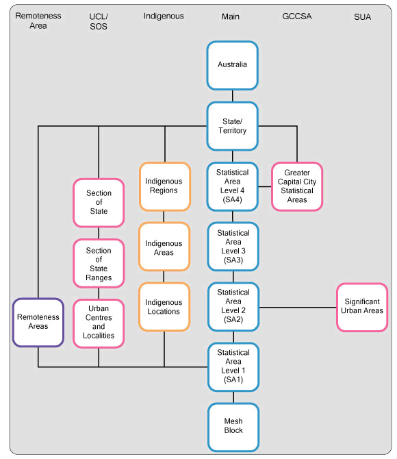
REGIONS OF THE ASGS
The ASGS brings all the regions used by the ABS to output data under the one umbrella. They are divided into two broad categories:
1. ABS structures, those regions which are defined and maintained by the ABS.
2. Non-ABS structures, those regions defined and maintained by other organisations, but for which the ABS releases data.
The ABS structures are a hierarchy of regions specifically developed for the release of particular ABS statistics described below.
ABS Regions
Mesh Blocks are the smallest area geographical region. There are approximately 348,000 covering the whole of Australia. They broadly identify land use such as: residential, commercial, agriculture and parks etc. Residential and agricultural Mesh Blocks usually contain 30 to 60 households. Mesh Blocks are the building block for all the larger regions of the ASGS. Only limited Census data, total population and dwelling counts will be released at the mesh block level.
Statistical Areas Level 1 (SA1s) will be the smallest region for which a wide range of Census data will be released. They will have an average population of about 400. They will be built from whole Mesh Blocks and there will be approximately 55,000 covering the whole of Australia.
Statistical Areas Level 2 (SA2s) will have an average population of about 10,000, with a minimum population of 3,000 and a maximum of 25,000. The SA2s are the regions for which the majority of ABS sub-state non-census data, for example Estimated Resident Population and Health and Vital Statistics, will be released. There will be about 2,200 SA2s, built from whole SA1s.
Statistical Areas Level 3 (SA3s) are a medium sized region with a population of 30,000 to 130,000. They represent the functional areas of regional cities and large urban transport and service hubs. They will be built from whole SA2s.
Statistical Areas Level 4 (SA4s) will be used for the release of Labour Force Statistics.
Urban Centres/Localities, Section of State and Remoteness Areas will define the built up area of Australia's towns and cities and will be broadly comparable to previous Censuses.
Greater Capital City Statistical Areas and Significant Urban Areas define the Capital Cities, major regional cities and towns of Australia with a population over 10,000. This includes both the built up area, any likely medium term expansion and their area of immediate economic influence.
Indigenous Regions, Areas and Localities are designed for the presentation of Indigenous data. At the Indigenous Locality level it is possible to identify data on particular Indigenous Communities.
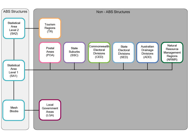
Non-ABS Regions
Non-ABS structures will be approximated or built directly from Mesh Blocks or SA1s. The Non-ABS structures include such important regions as: Local Government Areas (LGAs), postal areas, state gazetted suburbs and electoral divisions. LGAs remain part of the ASGS and the ABS will continue to support LGAs with the data it currently provides.
The diagrams below summarises the overall structure of the ASGS.
RELEASE OF THE ASGS
The Non-ABS structures will be released in mid 2011; this is to ensure that the Census is released on the most up to date boundaries available. Urban Centres and Localities, Section of State, Remoteness and Significant Urban Areas will be released in 2012 as they require an analysis of Census data to be developed.
The regions defined in the ABS structures will not change until the next Census in 2016, although the Non-ABS structures will be updated annually.
The ASGS will come into effect on the 1 July 2011.
Further Information
For more information please follow the link to the ABS Geography Portal. If you have any questions regarding the ASGS please email geography@abs.gov.au. |
 Print Page