4609.0.55.002 - Land Account: Victoria, Experimental Estimates, 2012
ARCHIVED ISSUE Released at 11:30 AM (CANBERRA TIME) 13/12/2012 First Issue
Page tools:
 Print Page Print Page
 Print All Print All
| ||||
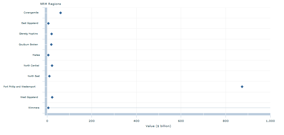
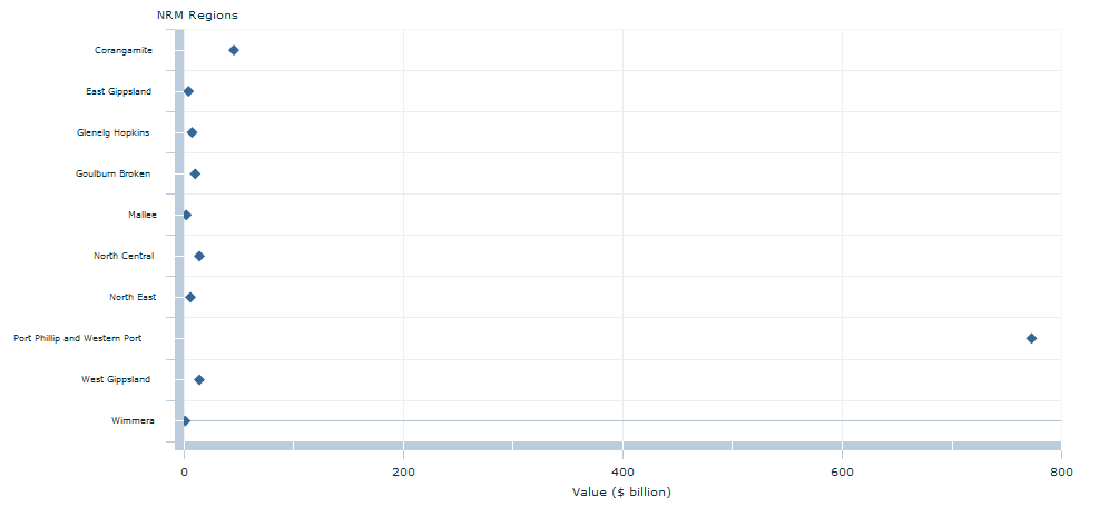
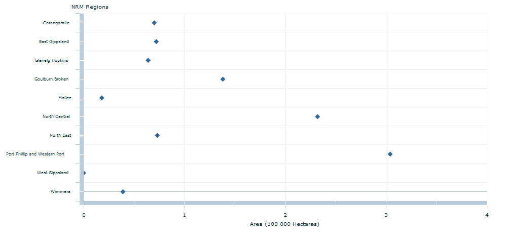
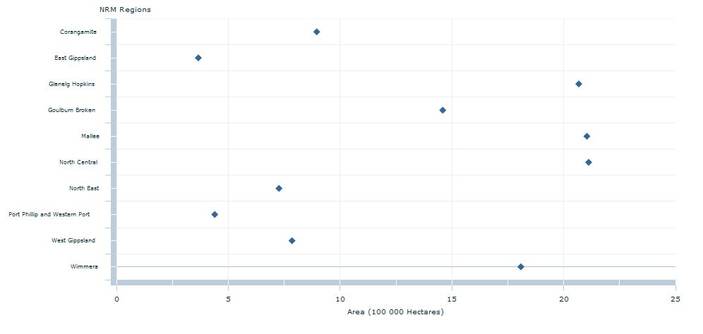
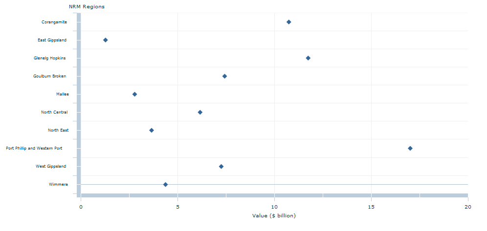
This release presents an experimental land account for the state of Victoria and the associated Natural Resource Management (NRM) regions. The State of Victoria, Australia (Figure 1) contains ten NRM regions: Corangamite, East Gippsland, Glenelg Hopkins, Goulburn Broken, Mallee, North Central, North East, Port Phillip and Westernport, West Gippsland and Wimmera. These NRM regions are shown in Figure 2. The total rateable value of land in Victoria as at June 2012 is valued at $1,047 billion and covers approximately 23 million hectares. While the area of land is shared relatively evenly between the ten NRM regions in Victoria, Port Phillip and Westernport dominates land value with a total of $874 billion (83%). Figure 3 presents the total rateable value of land for each NRM. Residential Land classified as Residential by the State of Victoria represents $878 billion or 83% of Victoria's total rateable value but only 5% of the state's total area. This land use was largely confined to the Port Phillip and Westernport NRM Region with a total residential value of $772 billion (Figure 4). In this NRM region, 303,709 hectares or 24% was classified as Residential land use (Figure 5). The Port Phillip and Westernport Natural Resource Management (NRM) region contains the majority of the Greater Melbourne Greater Capital City Statistical Area (GCCSA). At June 2011 the Estimated Resident Population (ERP) of the Greater Melbourne region represented approximately 75% of Victoria’s total population. This highlights the strong relationship between land value and population. Primary Production More than half of all land in Victoria has a land use classification of Primary Production (56%). The Glenelg Hopkins, Goulburn Broken, Mallee, North Central and Wimmera NRM regions each have over 1.4 million hectares (Figure 6) of land use classified as Primary Production. The NRM with the highest value of land used for Primary Production is Port Phillip and Westernport at $17 billion (Figure 7), despite having the second smallest area of land used for Primary Production in the state. The high value of Primary Production land reflects the high value horticultural crops grown in and around Melbourne, the close proximity to markets and infrastructure, and competition for land from the residential and industrial sectors. More information about the Value of Agricultural Commodities Produced (VACP) in regional areas is available from Value of Agricultural Commodities Produced, Australia, 2010–11 (ABS cat. no. 7503.0). Primary Production land use predominantly occurs on Rainfed Cropping and Rainfed Pasture land covers (4 and 5 million hectares, respectively). For example, 42% of the area of the Wimmera NRM is Rainfed Cropping land used for Mixed Farming and Grazing and 44% of the area of Glenelg Hopkins NRM is Rainfed Pasture used for Mixed Farming and Grazing. Rainfed refers to farming practices that solely rely on rainfall for water. The West Gippsland and Goulburn Broken NRM regions have the largest area of Irrigated Pasture in Victoria and the predominant uses on this land are Livestock Grazing and Mixed Farming. Livestock Grazing on Irrigated Pasture land cover accounts for 74,000 hectares in Victoria. The Goulburn Broken and North Central NRM regions contain the largest proportions of this land with 26,000 hectares or 35% and 18,000 hectares or 24% respectively. This reflects the significant irrigated dairy operations in these regions. The total rateable value of land used for Livestock Grazing on Irrigated Pasture land cover in Victoria is $626 million. The Port Phillip and Westernport NRM region is the largest in this sector with a total value of $139 million, 22% of the state total. Goulburn Broken and West Gippsland NRM regions have similarly high values at $125 million or 20%, and $97 million or 16% respectively. Statistical Area 1 Data A Statistical Area 1 (SA1) is a small statistical area used as the basis for the output of the Census of Population and Housing. Their area can range from a small city block to sparse agricultural or remote communities, usually with populations of 200 to 800 people. (See Figure 8) Land development and population growth The Estimated Resident Population (ERP) for Victoria increased by 8% between 2006 and 2011 to over 5.5 million people. Supporting this population growth were 220,000 new Cadastral parcels created in Victoria between 2006 and 2011. More than 80% (177,000) of these new parcels were less than 750sqm (0.075 ha) in area. Cadastral parcels of this size are predominantly associated with residential land use. The greatest increases in small (0-750sqm) residential sized land parcels and ERP were in SA1s around the outskirts of Melbourne. These SA1s were located in Melton and Bacchus Marsh to the west of Melbourne; Point Cook, Truganina and Tarneit to the south west; Cragieburn, Mickleham, Wallan and South Morang to the north; and Lynbrook, Lyndhurst and Cranbourne to the east of Melbourne (see Map 2 in the downloads tab). The SA1 in Victoria with the greatest increase in the number of small (0-750 sqm) residential sized land parcels from 2006 to 2011 was at Cragieburn where 2,592 parcels were added. These new residential sized parcels came in part from a loss of 5 Cadastral parcels greater than 100 hectares over this period. In line with this growth this SA1 had one of the greatest increases in new dwellings in Victoria in the 2011–12 financial year with 560 new dwellings and experienced the greatest population growth between 2006 and 2011, increasing by 6,500. The total value of all building approvals in this SA1 (including those with new dwellings) was also one of the highest in the state, totalling $114 million. An SA1 at Point Cook experienced a similarly large increase in the number of small (0-750sqm) residential sized land parcels with 2,524 added between 2006 and 2011. Complementing this land development was an increase in ERP of 4,400 people. The total value of all building approvals in this SA1 for the 2011–12 financial year was also one of the highest in Victoria with $93 million. Cadastral parcels sized between 0.4 and 10 hectares often include land used for residential purposes. This form of residential settlement is described with various names including "peri-urban", "rural residential" and "hobby farming" and is a growing phenomenon in many parts of Australia. Several regions in Victoria were identified with large increases in cadastral parcels sized between 0.4 and 10 hectares as residential land use (see Map 3 in the downloads tab). Some points to highlight about these cadastral parcel sizes are:
Document Selection These documents will be presented in a new window.
|
||||

