|
|
INTRODUCTION
1 For Australia, this publication contains estimates of the resident population of SLAs, LGAs, SSDs, SDs, Statistical Districts, states and territories, and Australia. For New Zealand, this publication contains estimates of the resident population of Regional Councils, Territorial Authorities and New Zealand.
2 LGAs are ranked within states and territories according to both largest growth (in number) and fastest growth (in percentage terms) between June 2002 and June 2003, allowing this publication to identify, in two ways, areas in Australia with the largest and fastest increases and decreases in population. Largest growth is based on the absolute change in population while fastest growth is based on the rate of change in population.
3 Following the 1992 amendment to the Acts Interpretation Act 1901-1973 to include the Indian Ocean Territories of Christmas Island and Cocos (Keeling) Islands as part of geographic Australia, population estimates at dates commencing from July 1993 include estimates for these two territories. To reflect this change, another category of the state/territory classification was created, known as Other Territories. Other Territories include Jervis Bay Territory, Christmas Island and the Cocos (Keeling) Islands. Prior to July 1993, Jervis Bay Territory was included in estimates for the Australian Capital Territory.
4 To meet the conflicting demands for accuracy and timeliness there are three estimates of sub-state/territory populations. Preliminary estimates are normally available eight months after the reference date (i.e. February), revised estimates a year later and final estimates after the following census. The Australian estimates in this publication are final for 1998, based on results of the 2001 Census of Population and Housing. The 2002 estimates have been revised, while the 2003 estimates are preliminary, based upon the final 2001 estimates.
5 In recognition of the inherent inaccuracy involved in population estimation, population figures less than 1,000 in the text and accompanying summary tables are rounded to the nearest ten, figures over 1,000 are rounded to the nearest hundred, and figures over 1 million are rounded to the nearest 100,000. While unrounded figures are provided in the main tables, accuracy to the last digit is not claimed and should not be assumed.
ESTIMATED RESIDENT POPULATION - AUSTRALIA
6 Estimated resident population (ERP) are estimates of the Australian population obtained by adding to the estimated population at the beginning of each period the components of natural increase (on a usual residence basis) and net overseas migration.
7 For the states and territories, account is also taken of estimated interstate movements involving a change of usual residence. After each census, estimates for the preceding intercensal period are revised by incorporating an additional adjustment (intercensal discrepancy) to ensure that the total intercensal increase agrees with the difference between the ERPs at the two respective census dates.
8 Estimates of the resident population are based on census counts by place of usual residence, with an allowance for net census undercount, to which are added the number of Australian residents estimated to have been temporarily overseas at the time of the census. Overseas visitors in Australia are excluded from this calculation.
9 The concept of ERP links people to a place of usual residence within Australia. Usual residence is that place where each person has lived or intends to live for six months or more from the reference date for data collection.
ESTIMATION OF SUB-STATE/TERRITORY POPULATIONS
10 In census years the ERP as at 30 June for each Statistical Local Area (SLA)/ Local Government Area (LGA) is based on usual residence census counts, with an allowance for net census undercount and the number of residents temporarily overseas at the census date. Overseas visitors in Australia are excluded from this calculation. As the census is held at a date other than 30 June (6 August in both 1991 and 1996, and 7 August in 2001), further adjustments taking into account births, deaths and net migration for the intervening period are made to obtain the ERP at 30 June.
11 For post-censal years, the absence of migration data at the SLA level means that it is not possible to estimate SLA populations by taking into account natural increase and net migration. Instead, ERPs are calculated using a mathematical model. Local knowledge, including that advised by local governments, may be used to adjust the outcome of the model for a particular SLA.
12 In the mathematical model a relationship is established between changes in population and changes in other indicators over the period between the two most recent censuses.
13 The choice of indicators varies across the states and territories, depending on availability, and includes dwelling approvals, electricity connections, Medicare enrolments and drivers' licences. Changes in these indicators are then used to estimate changes in the population of each area since the last census. The choice of indicators also varies across SLAs depending on aspects such as whether the SLA is urban or rural, is growing or declining, and whether the area has a high or low proportion of houses or medium and high density dwellings.
Estimating ERPs for new SLAs
14 The Australian Standard Geographical Classification (ASGC), 2003 (cat. no. 1216.0) introduced 29 new LGAs and corresponding SLAs in Northern Territory. These new geographic areas are based on Community Government Councils (CGCs) which are representative Indigenous bodies. Previously, the population of these areas were included within the former SLA (and LGA or unincorporated Northern Territory) boundaries defined in earlier versions of ASGC (see appendix 3 and 4). Similarly in Queensland, new LGAs and corresponding SLAs were introduced in 2002 for Aboriginal Council (AC) and Island Council (IC) areas (see appendix 1 and 2).
15 The 30 June 2001 ERPs for these new areas are based on 2001 Census of Population and Housing usual residence census counts as at 7 August 2001, adjusted for net undercount (including demographic adjustments), residents temporarily overseas and backdated to 30 June based on estimates of natural increase and net migration. Population estimates for these new areas which do not correspond to ASGC 2001-based SLAs are compiled by apportioning the 30 June 2001 ERP of the former SLA(s) to 2001 Census based Collection Districts (CDs) within each SLA using 2001 Census usual residence counts at the CD level. CDs, or aggregations of CDs which directly correspond to the new SLAs are then used to aggregate apportioned CD level population estimates to derive an estimated population of each of the new ASGC 2003-based SLAs. In some cases where new SLA boundaries do not correspond directly to 2001 Census CD boundaries, estimates are made as to the share of population to be allocated from the CD to each relevant SLA.
16 The SLA to CD level apportionment method for estimating census-year populations has some limitations. Estimates of net undercount are apportioned to SLAs based on age, sex, Indigenous status, state and territory, and (for the six states) capital city/balance of state. However, the SLA to CD level apportionment assumes that net undercount is distributed to component CDs in proportion to the census usual residence counts. It is quite possible that there may be local clustering and regional differences in net undercount which cannot be practically or efficiently measured. SLA level estimates of the number of residents temporarily overseas on census night are based on coding addresses of residence to SLA from a sample of incoming passenger cards. The apportionment process assumes these are distributed to CDs in proportion to the census usual counts. Data are not available retrospectively for the newly defined SLAs and LGAs for births and deaths between the 30 June and the census date. Similarly, no data are available on net migration for the new SLAs. Accordingly, the population estimates for new SLAs based on CD level apportionment are reasonable approximations in the absence of finer level components.
17 For the new Queensland AC and IC Areas, additional administrative and local knowledge was used to estimate for population change from 30 June 2001 to 30 June 2002 in the previous issue of this publication.
18 Unlike most SLA and LGAs in Australia, the ABS has not been able to estimate for population change for the new CGC LGAs and SLAs in the Northern Territory from 30 June 2001 to 30 June 2003, and the AC and IC LGAs and SLAs in Queensland from 30 June 2002 to 30 June 2003. At the present time the ABS has not been able to identify any data sources that can yield reliable and comprehensive information on annual population change for these small communities. For Queensland ACs and ICs a significant change occurred in a previously used data source limiting its suitability for estimating population change for these SLAs during 2002–03. Further, the small size and remoteness of some of these areas means that postcode address-based data sets are of limited use. The nature of postal delivery areas and the use of post box-based addresses which may not be a clear indication of place of residence also limits the utility of these data to estimate population change for these areas. Where ABS has not been able to estimate annual population change, the latest estimate has been represented as "n.p.".
19 Small populations are relatively more sensitive to small population changes which may not be detectable or quantifiable. However, larger populations contain much of this variability within the larger population.
20 For the time being, and in the absence of other reliable data sources, the ABS may only be able to produce population estimates for these SLAs and LGAs in census years using data from the five-yearly Census of Population and Housing. The ABS will continue to monitor the availability of other data sources for population change estimation in consultation with state, territory and local governments. For example, the inclusion of these areas in the ASGC will mean that in future, other data such as births and deaths by place of usual residence can be coded to these new geographic levels for future use in small area population estimation.
21 Population estimates for the new SLAs and LGAs for periods between 1996 and 2001 have been prepared using interpolation techniques between 1996 and 2001 census year-based estimates.
22 A more detailed explanation of the concept of ERP, as adopted by the ABS for official population estimates, is contained in Demographic Estimates and Projections: Concepts, Sources and Methods, Statistical Concepts Library, ABS web site <www.abs.gov.au>.
SERVICE POPULATIONS
23 Service population estimates are a different measure of population. They take into account seasonal itinerant populations which are not included in the ERP. Currently the ABS does not produce service population estimates but two working papers are available which investigate the concept and feasibility of such estimates. The working papers are available on the ABS web site <www.abs.gov.au> by selecting Themes, then Demography, then ABS Demography Working Papers (numbers 96/4 and 99/3).
CORRECTION OF PRISON DATA OF QUEENSLAND
24 For the 2001 Census of Population and Housing, most prison data was received for processing via electronic data files. During the post-processing evaluation cycle, it has been established that the male and female counts for Queensland prisons (only) were incorrectly captured. This has resulted in the publication of incorrect sex census counts for males and females for various Queensland geographical areas and as a consequence, the Australian population totals. For population estimates, revisions to Queensland have been applied over the financial year 2001-2002. Revised estimates for 30 June 2002 by age and sex and SLA/LGA is currently available. Revision to population estimates for the 1996-2001 intercensal period are not planned. However, information on the SLAs and LGAs and other geographic areas affected are available in the 2001 Census Working Paper - Fact Sheet: Correction of Prison Data of Queensland on the ABS web site <www.abs.gov.au>.
ESTIMATED RESIDENT POPULATION — NEW ZEALAND
25 The estimated resident population of New Zealand, and any area of New Zealand, at 30 June in the year of the latest census is based on the latest census usually resident population counts updated for net census undercount, the number of residents temporarily overseas on census night, births, deaths and net migration between census night and 30 June, and reconciliation with demographic estimates at ages 0–9 years.
26 Subsequent national population estimates are produced by updating previous estimates using births, deaths and external migration data for the current quarter.
Subnational population estimates
27 Subnational population estimates are produced annually, as at 30 June. The estimation of subnational resident population uses the same component methodology as is used for estimates of the total national population, but with the addition of an extra component — internal migration between the subnational areas of New Zealand.
28 As no data on current internal migration is available, internal migration is estimated indirectly, using 'symptomatic' data, including building consents, occupancy rates, full-time equivalent employment, numbers of people in institutions (e.g. prisons), armed forces data, and past internal migration (from the most recent intercensal period). This information is supplemented by information from Territorial Authorities and universities. More details are available on request from Manager, Demography Division, Private Bag 4741, Christchurch, New Zealand.
AUSTRALIAN STATISTICAL AREAS
29 This publication contains data presented according to the Australian Standard Geographical Classification (ASGC) 2003 edition. Under this classification, statistical areas are defined as follows:
Local Government Areas (LGAs). These areas are the spatial units which represent the geographical areas of incorporated local government councils, an Aboriginal or Island Council in Queensland, or a Community Government Councils in the Northern Territory. The various types of LGAs are Aboriginal Councils (AC), Areas (A), Boroughs (B), Cities (C), Community Government Councils (CGC), District Councils (DC), Island Councils (IC), Municipalities (M), Regional Councils (RegC), Rural Cities (RC), Shires (S), and Towns (T).
Statistical Local Areas (SLAs). These geographical areas are, in most cases, identical with, or have been formed from a division of, whole LGAs. In other cases they represent unincorporated areas. In aggregate, SLAs cover the whole of a state or territory without gaps or overlaps. In some cases legal LGAs overlap Statistical Subdivision boundaries and therefore comprise two or three SLAs (Part A, Part B and, if necessary, Part C).
Statistical Subdivisions (SSDs). These are of intermediate size, between SLAs and SDs. In aggregate, they cover the whole of Australia without gaps or overlaps. They are defined as socially and economically homogeneous regions characterised by identifiable links between the inhabitants. In the non-urban areas an SSD is characterised by identifiable links between the economic units within the region, under the unifying influence of one or more major towns or cities.
Statistical Divisions (SDs). These consist of one or more SSDs. The divisions are designed to be relatively homogeneous regions characterised by identifiable social and economic units within the region, under the unifying influence of one or more major towns or cities.
Statistical Districts. These consist of selected, significant, predominantly urban areas in Australia which are not located within a Capital City SD. Statistical Districts enable comparable statistics to be produced about these selected urban areas.
30 Further information concerning statistical areas is contained in Australian Standard Geographical Classification (ASGC), 2003 (cat. no. 1216.0).
31 For the purposes of this publication, all data refer to bounded areas as defined at 1 July 2003, and as incorporated in the 2003 ASGC.
MAPS
32 A complete series of maps showing the SLAs mentioned in this publication is available in Australian Standard Geographical Classification (ASGC), 2003 (cat. no. 1216.0).
33 The centre of population is one measure used to describe the spatial distribution of a population. The method of calculation used in this publication for the map on page 8 is based on the 'centroid' (i.e. centre) and population of each SLA in Australia. Latitude and longitude coordinates of the centroid of each SLA are multiplied by the SLA's estimated resident population to obtain weighted latitudes and longitudes. These are summed to obtain a weighted latitude and longitude coordinate for all Australia, then divided by the total population of Australia to obtain a single latitude and longitude coordinate, the centre of population.
AVERAGE ANNUAL RATE OF GROWTH
34 The average annual growth rate, r, is calculated as a percentage using the formula: 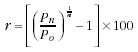
| A | Area |
| ABS | Australian Bureau of Statistics |
| AC | Aboriginal Council |
| ACT | Australian Capital Territory |
| ASGC | Australian Standard Geographical Classification |
| Aust. | Australia |
| B | Borough |
| Bal | Balance |
| BSB | Brisbane Statistical Division |
| C | City |
| CD | Collection District |
| CGC | Community Government Council |
| C. Goldfields | Central Goldfields |
| C'maine | Castlemaine |
| DC | District Council |
| ERP | estimated resident population |
| excl. | excluding |
| Gr. | Greater |
| IC | Island Council |
| incl. | including |
| km2 | square kilometre |
| LGA | Local Government Area |
| M | Municipality |
| M. Downs | Murrumba Downs |
| M'borough | Maryborough |
| Mt C'tha | Mount Coot-tha |
| no. | number |
| Norw. P'ham St Ptrs | Norwood, Payneham and St Peters |
| NSW | New South Wales |
| NT | Northern Territory |
| p | preliminary |
| Pt | Part |
| Port Pirie C, Dists | Port Pirie City and Districts |
| P'sula | Peninsula |
| Qld | Queensland |
| r | revised |
| RC | Rural City |
| RegC | Regional Council |
| Res. | Reservoir |
| S | Shire |
| SA | South Australia |
| S'bank-D'lands | Southbank Docklands |
| S C'st | Sunshine Coast |
| SD | Statistical Division |
| SLA | Statistical Local Area |
| S'saye | Strathfieldsaye |
| SSD | Statistical Subdivision |
| T | Town |
| Tas. | Tasmania |
| Unincorp. | Unincorporated |
| Vic. | Victoria |
| WA | Western Australia |
| Wtrs | Waters |
| . . | not applicable |
| — | nil or rounded to zero (including null cells) |
|
|
 Print Page
 Print All