Crop management practices in Australia were undertaken by 37,000 agricultural businesses (27% of all agricultural businesses) in 2011-12.
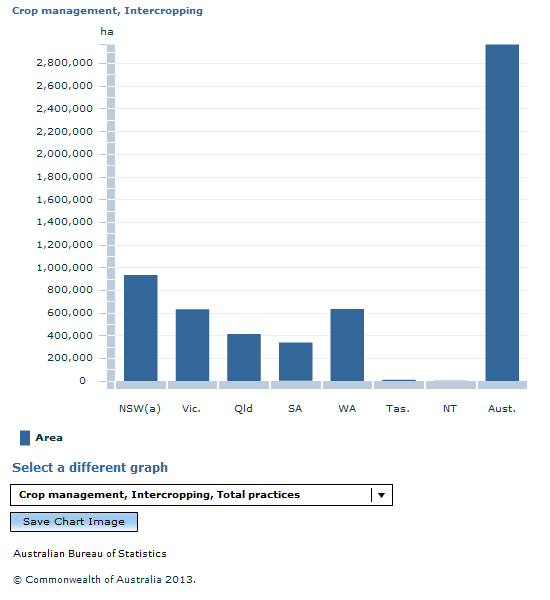
Intercropping was undertaken by approximately 10,000 agricultural businesses, utilising 3 million hectares of land. Although New South Wales covered the most intercropping area (934,000 hectares), Western Australia showed the highest average area per agricultural business (601 hectares per business) followed by Victoria (328 hectares per business).
Nationally, the most prevalent intercropping practice undertaken was mixed inter-row cropping, which accounted for half of all intercropping area (1.5 million hectares), while cover cropping accounted for around a quarter of intercropping area (736,000 hectares).
Victoria (457,000 hectares) and New South Wales (450,000 hectares) combined, reported approximately 60% of the mixed inter-row cropping total area.
The practice of crop rotation on pasture was carried out by approximately 10,000 agricultural businesses, covering 5.2 million hectares.
Of those businesses undertaking crop rotation using pasture only 1,800 agricultural businesses (17%) were in Western Australia , but they covered around 2.1 million hectares (40%) of area.
Crop management activity was most frequently reported in the Wheatbelt East (6,700 businesses) and Wheatbelt Central (5,600 businesses) regions.
Wheatbelt West (50%) and Wheatbelt North (39%) were the regions with the highest proportion of businesses conducting crop management practices (see map below).
INTERCROPPING
Mixed inter-row cropping was most commonly reported in the Wheatbelt East region, being undertaken on around 428,000 hectares.
Cover cropping was undertaken most predominantly in the Wheatbelt West region, accounting for nearly 217,000 hectares.
Strip cropping was less commonly reported, with the largest area of around 55,000 hectares reported in the Wheatbelt Downs region.
PASTURE FOR CROPPING
Pasture was sown on cropping land as part of a rotation most frequently in the Wheatbelt East region, covering around 463,000 hectares. The Wheatbelt West region had the highest proportion of businesses undertaking this practice (23%) (see map below).
Document Selection
These documents will be presented in a new window.
 Quality Declaration
  Print Page
 Print All